Início » Cenarium Rondônia » Despite record recovery in water volume, Brazil continues ‘drying up’
Despite record recovery in water volume, Brazil continues ‘drying up’
The country concentrates 6% of the entire water surface and 12% of the freshwater reserves on the planet (Sesc Pantanal/Reproduction)
Compartilhe:
February 16, 2023
Iury Lima – from Cenarium Magazine
VILHENA (RO) – “Brazil is drying up”. This is the conclusion of the MapBiomas network, which evaluated the loss of water resources in more than 30 years. Enough time for 1.5 million hectares of water surface to disappear from the country, according to a study released on Wednesday, 15.
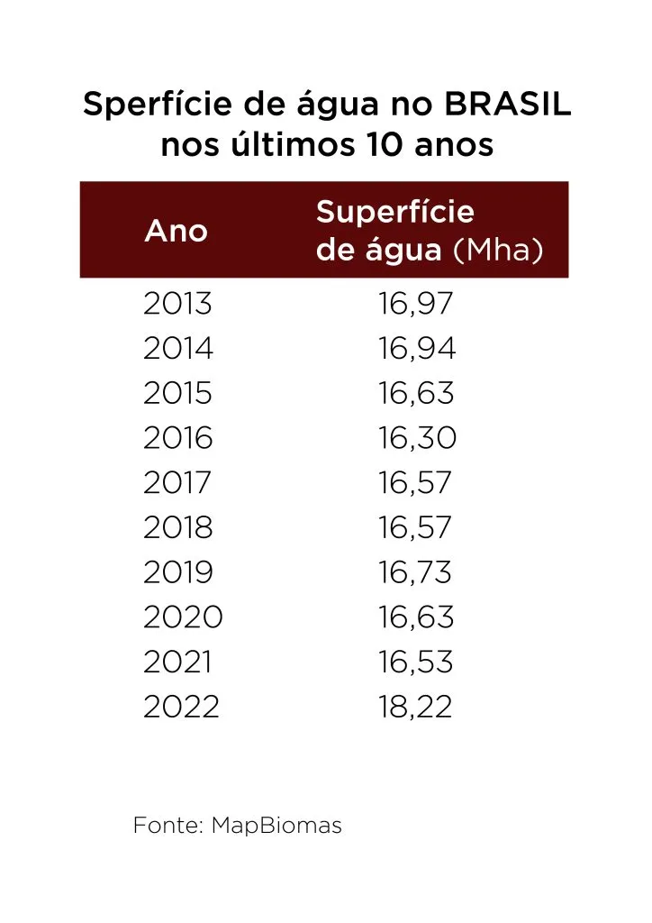
The exception was last year, which ended with the recovery of 1.7 million hectares of water bodies. A 10% increase in relation to 2021, which was the year with the smallest surface area in the historical series that began in 1985. Therefore, the country was 1.5% above the average, which is 17.9 million hectares covered by water. Seen as a “relief” for the researchers, 2022 was the first year, in almost a decade, in which the water surface in Brazil exceeded the mark of 16 million hectares.
Among the biomes, despite being the fourth largest water loser over the last three decades, the Amazon was the second ecosystem that recovered the most water volume in 2022: 6.2%, followed by the Cerrado, which gained 11%. On the other hand, the Pantanal is still going through a dry period and the Pampa has reached the lowest level of abundance since the survey began.
PUBLICIDADE
Besides impacting wildlife, the drop in water volume and quality generates more fires, especially in the Pampa and Pantanal (Edu Fragos/Reproduction)
Today, the country has 2% of its territory covered by water, an area equivalent to four times the state of Rio de Janeiro. Altogether, Brazil concentrates 6% of the entire water surface and 12% of the freshwater reserves on the planet.
The most critical decade
CENARIUM heard from a team of experts on the subject, who evaluate the data and its impacts on biodiversity. They are the technical coordinator of MapBiomas Água, Juliano Schirmbeck; journalist and advisor of the Instituto do Homem e Meio Ambiente da Amazônia (Imazon), Fernanda Costa, and WWF-Brazil Conservation Specialist, Helga Correa.
“The change in the scenario from 2021 to 2022 generates, yes, an encouragement, but we would not put it as a reason for celebration, we are observing an almost constant reduction in the water surface in Brazil,” the researchers warn.
Despite the “sign of recovery that 2022 represented,” the indicators point to a predominant trend of reduction in water availability in Brazil. According to the collaborative network, the interval between 2013 and 2021 encompasses the ten years with the lowest water surface area, evidencing that the last decade was the most critical.
The last decade was the most critical for the loss of areas covered by water in the country, according to the MapBiomas network (Thiago Alencar/CENARIUM)
“It is worth noting that the monitoring of the water surface is the monitoring of a cyclical phenomenon, where we have variations within a year itself, with drier months and other wetter months,” they explain.
One example is that from 2017 to 2020, seven out of 12 months of the year were below the annual average volume. The study sustains that 2022 was an exception because, in every month of that year, there was an increase in the water surface compared to 2021.
The survey also highlights that even with this general increase in 2022, 33%, that is, one third of the basins and hydrographic regions in the country had a loss of water, below the historical average. And it associates the gain of surfaces, in some cases, to hydroelectric plants, like the Araguaia-Tocantins basin. 17% of the Brazilian territory had a loss and 21% had a gain.
Illegal deforestation and illegal mining also negatively impact water availability in Brazil (Reproduction)
Another factor driving the volume variation is the rainfall regime. “We observed an increase in precipitation events in a large part of the country, with above average rainfall. This has brought about the recovery observed in our data, but we are living in times of climate change, which indicate that, increasingly, we will have extreme events and situations. We are also going through a La Ninã event, which influences the rainfall regime in Brazil, reducing rainfall in the south of the country and increasing it in the central and northern parts”, the specialists detail.
The driest biomes
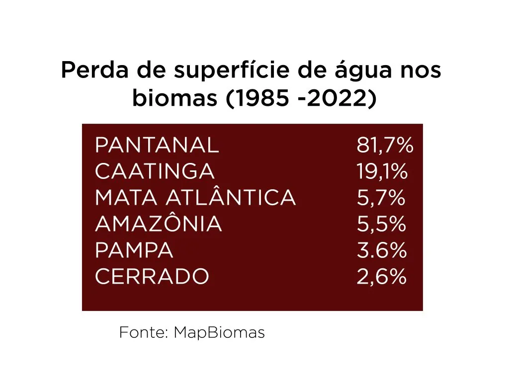
According to the study, all Brazilian biomes lost water between 1985 and 2022. The most critical situation is the Pantanal, which had a drop of 81.7% in these 37 years. Next comes the Caatinga, with a loss of 19.1%, that is, one fifth of its water surface. In third place is the Atlantic Forest, with a fall of 5.7%, followed by the Amazon, with 5.5%, the Pampa, 3.6%, and the Cerrado, 2.6%.
The result of the drought in the Pantanal was the leadership of Mato Grosso do Sul among the states with the greatest loss of water resources.
Pantanal and Caatinga lead the loss of biome water surfaces between 1985 and 2022 (Thiago Alencar/CENARIUM)
Already in 2022, the water surface in the biomes was above the average of the historical series, except in the Pampa and Pantanal.
“For both biomes, the quantity and quality of existing water is determinant for the existence of local biodiversity. Species that live in the rivers are impacted by the reduction of habitat [water quantity], but are also affected by factors such as reduction of water quality, caused by the entry of soil and pollution coming from deforested areas. All this affects the survival and reproduction conditions of aquatic species,” point out Juliano Schirmbeck, Fernanda Costa, and Helga Correa.
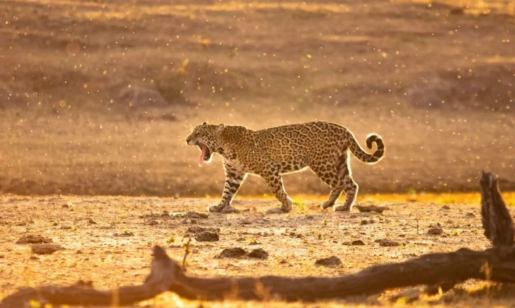
To the same extent, terrestrial animals also pay the bill, according to the researcher. These are species such as the jaguar, which “depends on the productivity of flooded areas in the Pantanal to ensure the abundance of prey,” he explains. “In addition, we can cite the negative impact that economic activities such as ecotourism and sport fishing suffer, affecting the possibilities of local economic development,” they evaluate.
Another negative result is the increase in the occurrences of fires in both the Pantanal and Pampa, due to the drought.
The Amazon Situation
In the largest tropical forest on the planet, the increase was 13% compared to 2021, which left the biome with a water surface area of more than 11 million hectares. The region was responsible for the fifth largest water surface area mapped in the survey. However, the trend is still downward.
“Although the Amazon saw its water surface area increase in 2022 because of the greater occurrence of rainfall, due to La Niña, this was the first year in which the biome had its water surface area above average, after 12 consecutive years below average,” the researchers compare. “We can say that the Amazon is still drying up,” they tell CENARIUM.
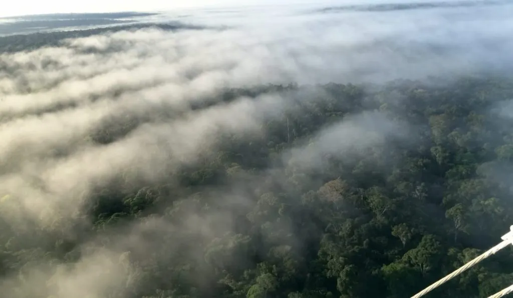
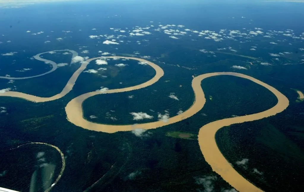
Aerial view of the Amazon River, the largest in the world in water volume and territorial extension (Chico Batata/Reproduction)
According to the MapBiomas, Imazon and WWF spokespersons, during the entire mapping period, the biome spent 23 years with water surface area below the average, 14 years above the average and, one year only, in the average of the historical series.
“This is extremely worrying for the Amazon, because the lives of various traditional peoples and communities depend directly on water, such as indigenous people, riverbank dwellers, extractivists and quilombolas,” they said.
“Rivers are a means of food, income generation, and transportation for these groups, including access to basic health and education services. Besides this, the drought in the Amazon damages the productivity of floodplain cultures, such as the açaí, an important product of the biome’s socio-biodiversity”, they also emphasized.
Deforestation and mining
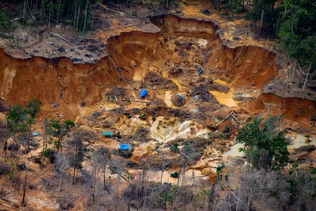
The health and humanitarian crisis experienced by the Yanomami indigenous people, caused especially by mining, as well as the advance of illegal deforestation, which will exceed 11 thousand square kilometers in 2022, in the Amazon, are also linked to the reduction in the availability of water in the country.
“We know that the rainfall regime in most of Brazil is governed by the so-called flying rivers, which consist of the forest’s ecological service of releasing water vapor into the atmosphere through the process of evapotranspiration. This vapor is carried by winds that collide with the Andes Mountains and deflect towards the central region of Brazil. Knowing this pattern of rain formation, we can say that the preservation of the Amazon Rainforest, that is, the reduction of deforestation, helps us to preserve the country’s water resources”, defend the specialists heard by the report.
Illegal mining site in the region of the Uraricoera River, on Yanomami land in Roraima, produces immense clearing of destruction (Release/Isa)
A cross-section of the MapBiomas study shows that 8% of the water available in the Yanomami Indigenous Land (TI) is at least 1 kilometer away from illegal mining. More than 1 million hectares of water resources are under threat.
“Therefore, in addition to national actions, we need measures focused on the Amazon reality for the protection of rivers, especially in protected areas”, he concludes.
Read also: Two out of ten endangered species are in Brazil; 70% of wildlife has disappeared in 50 years
Os comentários são de responsabilidade exclusiva de seus autores e não representam a opinião deste site. Se achar algo que viole os termos de uso, denuncie. Leia as perguntas mais frequentes para saber o que é impróprio ou ilegal.
This website uses cookies so that we can provide you with the best user experience possible. Cookie information is stored in your browser and performs functions such as recognising you when you return to our website and helping our team to understand which sections of the website you find most interesting and useful.
Strictly Necessary Cookies
Strictly Necessary Cookie should be enabled at all times so that we can save your preferences for cookie settings.
If you disable this cookie, we will not be able to save your preferences. This means that every time you visit this website you will need to enable or disable cookies again.